Languages
Languages
Languages


KDU-0171
PVC
57.5X45.5X2 cm
0.2kg
+3
Education
White Box
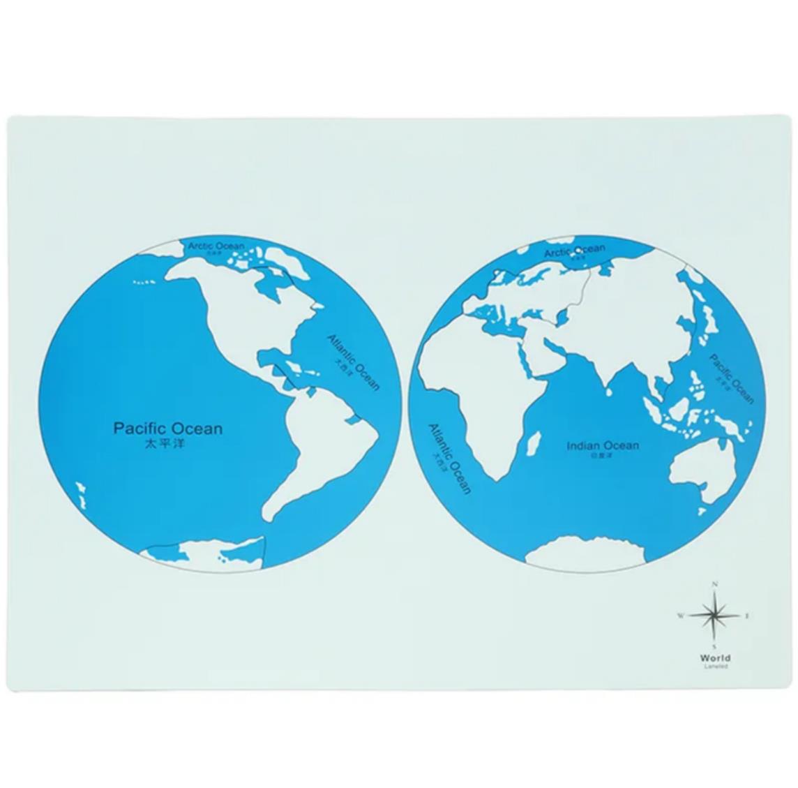
MOLTT World Hemisphere Map: A Two-Perspective Introduction to Global Geography
Product Overview
The MOLTT World Hemisphere Map presents a classic double-hemisphere projection of the Earth, serving as a foundational tool in Montessori cosmic education. This carefully designed material moves beyond a single global view to offer children two complementary perspectives of our planet's surface. By visualizing the Earth split into its Eastern and Western halves, it provides a clear, manageable framework for children to begin grasping the vastness of the world, the distribution of land and water, and the relative positions of continents and oceans.
Educational Purpose & Geographic Value
This material is specifically crafted to build a child's global awareness and spatial understanding. Its core objectives are to:
Introduce Continental & Oceanic Geography: Provide a direct visual reference for learning the names, shapes, and locations of the continents and major oceans.
Develop Mapping Skills & Perspective: Help children understand how a three-dimensional sphere is represented on a two-dimensional plane and how different map projections (like the hemisphere view) can be used.
Foster Comparative Analysis: By seeing the Earth divided into two halves, children can easily compare and contrast the landmass concentration, ocean sizes, and continental arrangements between the Eastern and Western Hemispheres.
Design & Key Features
The map is distinctly divided into two panels, each offering a focused geographic view:
The Western Hemisphere (Left Panel):
Continents Featured: North America and South America.
Oceans Featured: The vast Pacific Ocean is prominently displayed, along with parts of the Atlantic and Arctic Oceans.
The Eastern Hemisphere (Right Panel):
Continents Featured: Europe, Africa, Asia, and Australia/Oceania.
Oceans Featured: The Atlantic Ocean, Indian Ocean, and parts of the Pacific Ocean.
This clear separation isolates complex information, allowing the child to study one hemisphere at a time before synthesizing them into a complete mental model of the world.
Integration with the Montessori Curriculum
This Hemisphere Map is not used in isolation but as a key part of a sequenced geography curriculum:
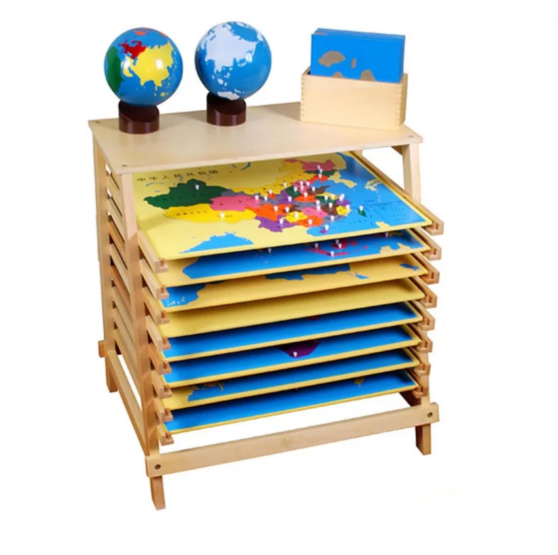
Progression from the Globe: It is typically introduced after the child has worked with the Montessori globes (Sandpaper Globe and Colored Continent Globe), providing a logical next step towards flat map representation.
Preparation for Puzzle Maps: It serves as a vital reference and bridge to the more detailed Puzzle Maps of Continents and the World. Children use the hemisphere map for overall orientation before engaging in the hands-on, country-level detail of the puzzle maps.
Hands-On Learning Catalyst: Through guided activities, children trace continents, match names to forms, and tell stories about different regions, transforming passive looking into active, sensorimotor learning.
Ideal Learning Context
An essential material for the Montessori early childhood and elementary geography area. It is perfectly suited for:
Classroom Demonstrations & Group Lessons: Its clear, large format is ideal for group discussion and instruction.
Homeschool Settings: Provides a classic, professional-grade reference map for world studies.
Individual Exploration: Children can work independently to reinforce continent names, conduct simple "map quests," or compare the hemisphere view with a standard world map or globe.
By offering a dual-perspective gateway to the world, the MOLTT World Hemisphere Map builds a critical foundation for geographic literacy, nurturing a child's curiosity about distant lands and cultures and their place within our interconnected planet

 mike@kidbu.com
 0086-57981589552
 No.97 Road of Fuxing, Bailong Street, Yunhe, Lishui City, Zhejiang, China.
Copyright © 2009-2025 MOLTT All Right Reserved. Designed & SEO by followala.cn Sitemap | XML
Sennl.com Montessori Tents: Sport Tent | Role Playing Tent | Triangle Tent | House Tent | Paintable Tent | Baby Pet Interaction Tent